 Geopal
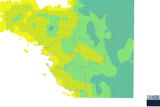
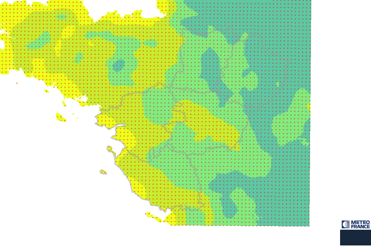
Nombre moyen annuel de jours de gel sur le Grand Ouest - Période 1981-2010 - Cartographie
Une journée est comptée comme jour de gel lorsque la température minimale observée sur cette journée est inférieure ou égale à 0°C sous abri.
La méthode de spatialisation utilisée est une méthode de résolution fine (1 km) prenant en compte le relief (méthode AURELHY) et appliquée aux observations relevées sur la période 1981-2010.
La période 1981-2010 constitue la dernière période de référence en cours, qui correspond à la durée recommandée par l'Organisation Météorologique Mondiale pour établir des statistiques climatologiques.
Simple
Identification info
- Date (Publication)
- 2012-12-03T12:27:00
- Régions de France
-
- PAYS-DE-LA-LOIRE
- BASSE-NORMANDIE
- BRETAGNE
- Theme
-
- Météo-France
- Theme
-
- données ouvertes
- theme.prodige.rdf
-
- GRAND PUBLIC
- AUTORITES_PUBLIQUES
- CLIMATOLOGIE
- METEO France
- Classification
- Unclassified
- Service Type
- invoke
- Description
- Région Grand Ouest
))
- Coupling Type
- Tight
Contains Operations
- Operation Name
- Accès à la carte
- Distributed Computing Platforms
- Web services
- Connect Point
- https://catalogue.sigloire.fr/geosource/consultation?id=105000 ( WWW:LINK-1.0-http--link )
Contains Operations
- Operation Name
- Accès au fichier contexte OWS de la carte
- Distributed Computing Platforms
- Web services
- Connect Point
- https://carto.sigloire.fr/frontcarto/context/getOws/105000 ( WWW:LINK-1.0-http--link )
Contains Operations
- Operation Name
- Accès au fichier PDF de la carte
- Distributed Computing Platforms
- Web services
- Connect Point
- https://carto.sigloire.fr/frontcarto/export/getPdf?id=105000 ( WWW:LINK-1.0-http--link )
- Reference system identifier
- EPSG / RGF93 / Lambert-93 (EPSG:2154) / 7.4
- OnLine resource
-
Accès à la carte
(
WWW:LINK-1.0-http--link
)
Accès à la carte
- OnLine resource
- https://public.meteofrance.com ( WWW:LINK-1.0-http--link )
- OnLine resource
-
Accès au fichier contexte OWS de la carte
(
WWW:LINK-1.0-http--link
)
Accès au fichier contexte OWS de la carte
- OnLine resource
-
Accès au fichier PDF de la carte
(
WWW:LINK-1.0-http--link
)
Accès au fichier PDF de la carte
- Hierarchy level
- Service
- File identifier
- 1163d032-b3c5-4475-9c2b-954667bbbd7c XML
- Metadata language
- fre
- Character set
- UTF8
- Parent identifier
- Atlas Climatologique Régional du Grand Ouest 37e4ba8f-f994-414e-a295-e9a9ce794a13
- Hierarchy level
- Service
- Hierarchy level name
- service
- Date stamp
- 2016-03-25T11:01:21
- Metadata standard name
- ISO 19115:2003/19139
- Metadata standard version
- 1.0
Overviews
Spatial extent
Provided by
