 Geopal
Carte administrative
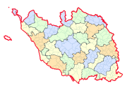
Carte des limites administratives de Vendée.Communes - EPCI - Cantons.
Simple
Identification info
- Date (Publication)
- Departement
-
- VENDEE
- Theme
-
- 02 - Vendée
- Géo Vendée
- Theme
-
- Ouvert
- Grand public
- Theme
-
- Référentiels
- Limtes administratives
- theme.thématiques.rdf
-
- Administratif
- Service Type
- invoke
- Coupling Type
- Tight
Contains Operations
- Operation Name
- Accès à la carte
- Distributed Computing Platforms
- Web services
Contains Operations
- Operation Name
- Accès au fichier contexte OWS de la carte
- Distributed Computing Platforms
- Web services
- Connect Point
- http://carto.geovendee.fr/services/GetContext/index.php?id=20 ( WWW:LINK-1.0-http--link )
Contains Operations
- Operation Name
- Accès au fichier PDF de la carte
- Distributed Computing Platforms
- Web services
- Connect Point
- http://carto.geovendee.fr/services/GetPDF/index.php?id=20 ( WWW:LINK-1.0-http--link )
- Reference system identifier
- EPSG / RGF93 / Lambert-93 (EPSG:2154) / 7.4
- OnLine resource
- http://www.geovendee.fr/catalogue/consultation.php?id=20
- OnLine resource
- Accès au fichier contexte OWS de la carte ( WWW:LINK-1.0-http--link )
- OnLine resource
- Accès au fichier PDF de la carte ( WWW:LINK-1.0-http--link )
- Hierarchy level
- Service
Overviews
thumbnail

large_thumbnail
Spatial extent
Provided by

Associated resources
Not available