 Geopal
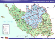
Carte PDF - Ancienne carte administrative de la Vendée.
Carte administrative de Vendée avant le Décret n° 2014-169 du 17 février 2014 sur le redécoupage cantonal.
Éléments représentés: Préfecture, sous-préfecture, chef lieu de canton, limite cantonale, limite communale, limite départementale, Arrondissement.
Simple
Identification info
- Date (Publication)
- Departement
-
- VENDEE
- theme.thématiques.rdf
-
- Administratif
- Theme
-
- 02 - Vendée
- Géo Vendée
- Theme
-
- Ouvert
- Grand public
- Theme
-
- Métiers
- Démographie
- Classification
- Unclassified
- Service Type
- invoke
- Description
- VENDEE
N
S
E
W
))
- Coupling Type
- Tight
Contains Operations
- Operation Name
- Accès à la carte
- Distributed Computing Platforms
- Web services
- Connect Point
- http://www.geovendee.fr/catalogue/consultation.php?id=5716 ( WWW:LINK-1.0-http--link )
- Reference system identifier
- EPSG / RGF93 / Lambert-93 (EPSG:2154) / 7.4
- OnLine resource
- Accès à la carte ( WWW:LINK-1.0-http--link )
- Hierarchy level
- Service
- File identifier
- 476e3069-c139-43b3-9b7e-237b1fab2cdb XML
- Metadata language
- fre
- Character set
- UTF8
- Hierarchy level
- Service
- Hierarchy level name
- service
- Date stamp
- 2015-09-04T09:49:12
- Metadata standard name
- ISO 19115:2003/19139
- Metadata standard version
- 1.0
Overviews
thumbnail

large_thumbnail
Spatial extent
N
S
E
W
Provided by

Associated resources
Not available