 Geopal
Study of the distribution of eelgrass beds in the region Pays de la Loire by multispectral image
Simple
- Date (Publication)
- 2015-01-23T12:00:00
- Identifier
- https://ids.osuna.univ-nantes.fr/geonetwork/srv/resourcesa14256c9-a00c-40a5-83a0-29b5005a4be2
- Status
- Completed
- Maintenance and update frequency
- Not planned
- Theme
-
- multispectral image
- Continents, countries, sea regions of the world.
-
- France
- Place
-
- Pays de la Loire
- Keywords
-
- OSUNA
- GEMET - Concepts, version 2.4
-
- biomass
- geo-referenced data
- GEMET - INSPIRE themes, version 1.0
-
- Species distribution
- Use limitation
-
The supply partner is not in a position to guarantee the accuracy, up-to-dateness, integrity, completeness of the data and in particular that it is free from errors or inaccuracies, in particular with regard to location, identification or qualification. No guarantee is given by the supplying partner as to the suitability of the data for a particular purpose. Users use the data under their own responsibility, without any recourse against the partner supplier, who cannot be held liable for any damage resulting directly or indirectly from the use of these data. In particular, it is up to the users to assess, under their sole responsibility: the appropriateness of using the data; the compatibility of the files with their computer systems; the adequacy of the data to their needs; that they have sufficient competence to use the data. The partner supplier is not responsible for any elements outside the data, in particular the analysis tools, hardware, software, networks, etc., used to consult and/or process the data. The user shall ensure that the information made available is up to date and compatible with the use he/she makes of it.
Free use subject to the obligatory mentions on all distribution documents: "Source: under the direction of the OSU Nantes Atlantique".
The data is provided under the Open License 2.0 (https://www.etalab.gouv.fr/wp-content/uploads/2018/11/open-licence.pdf).
- Access constraints
- Other restrictions
- Use constraints
- License
- Spatial representation type
- Vector
- Metadata language
- fre
- Character set
- UTF8
- Topic category
-
- Environment
- Description
- Région Pays de la Loire
))
- Begin date
- 1991
- End date
- 2005
- Reference system identifier
- EPSG / lambert 93 / 7.9
- Distribution format
-
-
ESRI Shapefile
(
1.0
)
-
ESRI Shapefile
(
1.0
)
- OnLine resource
-
ndvi_bourgneuf_1991
(
OGC:WMS-1.3.0-http-get-map
)
Distribution spatiale des zostères par rangs de valeurs de NDVI - 1991
- OnLine resource
-
ndvi_bourgneuf_1993
(
OGC:WMS-1.3.0-http-get-map
)
Distribution spatiale des zostères par rangs de valeurs de NDVI - 1993
- OnLine resource
-
ndvi_bourgneuf_1996
(
OGC:WMS-1.3.0-http-get-map
)
Distribution spatiale des zostères par rangs de valeurs de NDVI - 1996
- OnLine resource
-
ndvi_bourgneuf_1997
(
OGC:WMS-1.3.0-http-get-map
)
Distribution spatiale des zostères par rangs de valeurs de NDVI - 1997
- OnLine resource
-
ndvi_bourgneuf_1998
(
OGC:WMS-1.3.0-http-get-map
)
Distribution spatiale des zostères par rangs de valeurs de NDVI - 1998
- OnLine resource
-
ndvi_bourgneuf_2005
(
OGC:WMS-1.3.0-http-get-map
)
Distribution spatiale des zostères par rangs de valeurs de NDVI - 2005
- OnLine resource
-
biomasse_bourgneuf_2005
(
OGC:WMS-1.3.0-http-get-map
)
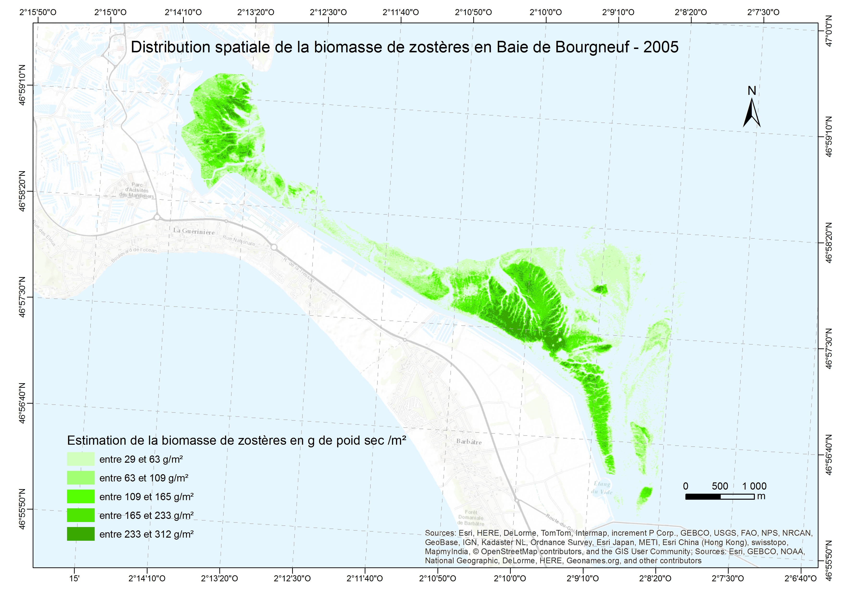
Cartographie de la biomasse de zostères en Baie de Bourgneuf - 2005
- OnLine resource
- Digital Object Identifier (DOI) ( DOI )
- OnLine resource
- https://geoserver.osuna.univ-nantes.fr/geoserver/SOHLA/wfs ( OGC:WFS-1.0.0-http-get-capabilities )
Data quality info
- Hierarchy level
- Series
Domain consistency
Conformance result
- Date (Publication)
- 2010-05-31
- Explanation
- Ressource concernée par INSPIRE
- Pass
- No
Conformance result
- Date (Publication)
- 2010-05-31
- Explanation
- -- information sur le test --
- Pass
- No
- Statement
-
Fields eelgrass, which fall into seagrass beds in sandy sediments, or in estuaries, are one of the most productive ecosystems on Earth and play a very important role in the functioning of marine ecosystems. The large eelgrass beds are indeed very important in terms of food and habitat especially for the fry of many species. They also play an essential role in stabilizing the sediment as well as the water quality. They should be followed over the long term in order to achieve good management of these sites.
The study was conducted on six images acquired by the Spot satellite between 1991 and 2005, during the summer at low tide and cloudless (20m resolution (1991 images, 1993, 1996, 1997, 1998) and 10m (SPOT 2005)).
The images were converted into ground reflectance with the method known as Empiric Line Correction (Méléder, 2003). A geographical mask, based on bathymetry, rocky areas and oyster beds, was applied to images in order to take into consideration that the area in intertidal sandy mud sediment where seagrasses develop.
Spectral signatures of measurements were obtained in the field with a spectroradiometer FieldSpec ASD. The spectral responses of the main macrophytes and sediments found in the intertidal area were recorded in the near infrared visible between 400 and 900nm. Meanwhile, a working spectroradiometric measures was conducted in the laboratory to test the ability of NDVI (Normalized Difference Vegetation Index) to estimate the biomass of eelgrass leaves in g / m².
The NDVI is calculated as follows from the tapes Near Infrared and Red SPOT images converted into reflectance (NIR - R) / (NIR + R).
Vegetation indices are presented in class: low index (0.2 to 0.4) and high index (0.4 to 0.7) for 6 dates. Biomass card is obtained after the work of field and laboratory with the following relationship:
Biomass = 610.61 (NDVI) 1.88 (n = 31, r ² = 0.97)
- File identifier
- a14256c9-a00c-40a5-83a0-29b5005a4be2 XML
- Metadata language
- fre
- Character set
- UTF8
- Hierarchy level
- Series
- Hierarchy level name
- ensemble de séries de données
- Date stamp
- 2023-04-17T15:56:55
- Metadata standard name
- ISO 19115:2003/19139
- Metadata standard version
- 1.0
Overviews
Spatial extent
Provided by
