 Geopal
series
Domaines
Harvested
Provided by
Type of resources
Available actions
Topics
Keywords
Contact for the resource
Provided by
Years
Formats
Representation types
Update frequencies
status
Scale
Resolution
-
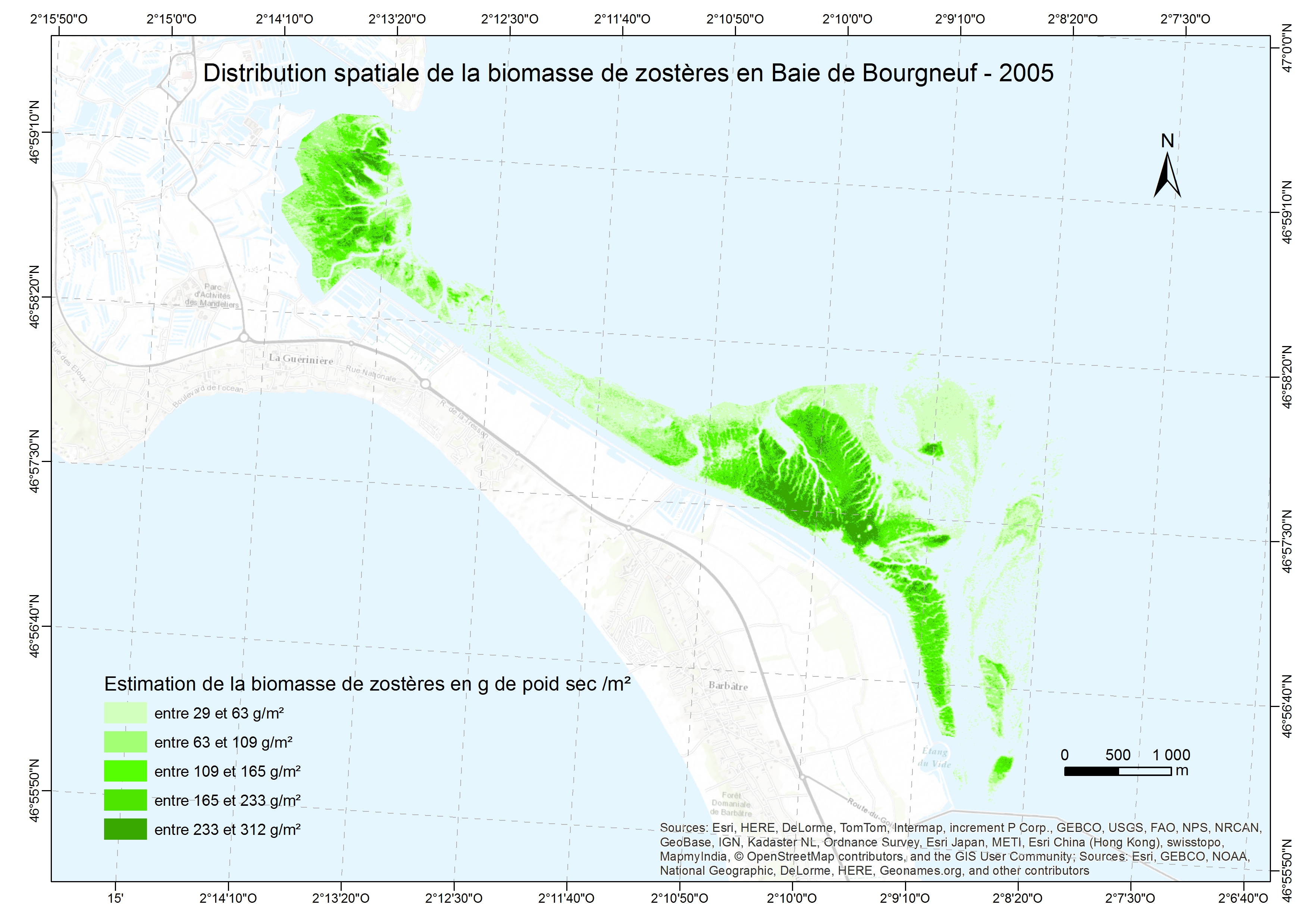
Exploring the feasibility of monitoring the evolution of the spatial distribution of intertidal eelgrass from multispectral images combined with measures spectroradiometric land in confined areas. This spatial distribution for the amount of intertidal eelgrass present through the calculation of a vegetation index . This vegetation index can then be connected to the biomass.
-
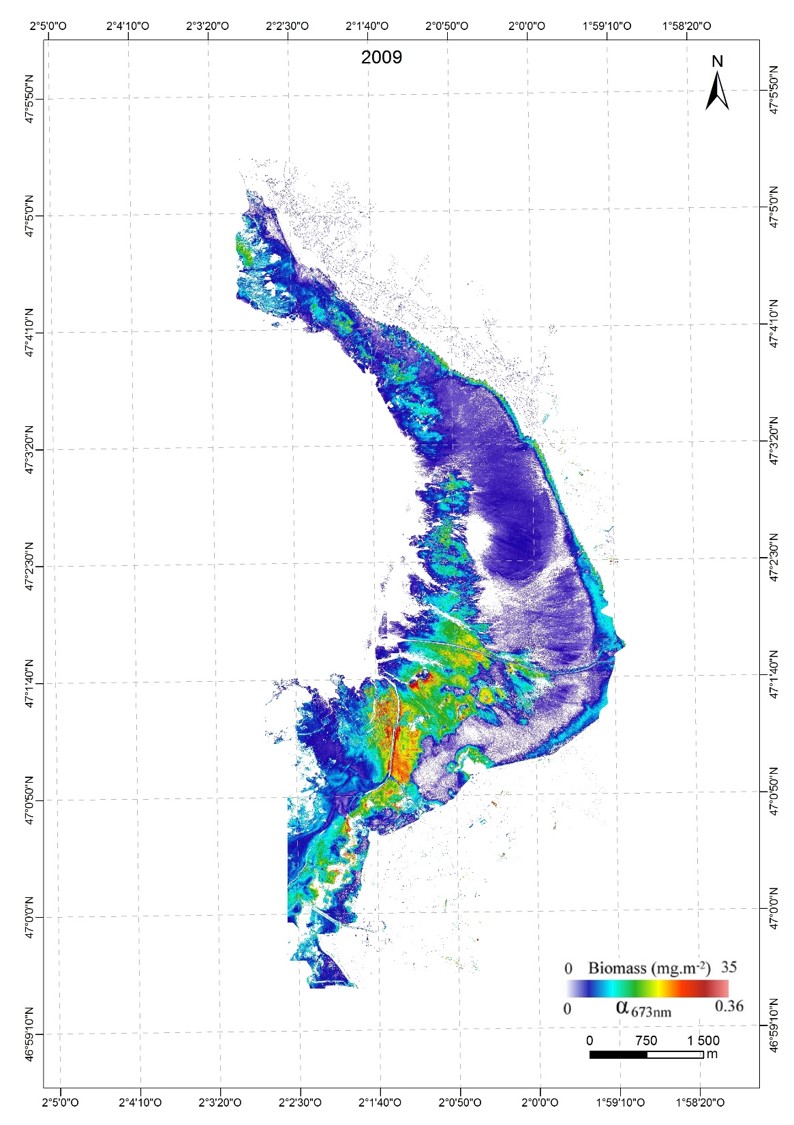
A new approach to mapping based on an optical model was developed and used from hyperspectral aerial images to determine the biofilm microphytobenthos and estimate their biomass in confined mudflats
-

Liste des communes, EPCI et syndicats mixtes portant un Plan Climat-Énergie Territorial (PCET) - obligatoire ou volontaire - en région Pays de la Loire. Un PCET est un projet territorial de développement durable qui a pour finalité la lutte contre le changement climatique. Institué par le Plan Climat national et repris par les lois Grenelle, c’est un cadre d’engagement pour le territoire. Le PCET vise deux objectifs : l’atténuation : limiter l’impact du territoire sur le climat en réduisant les émissions de gaz à effet de serre (GES) ; l’adaptation : réduire la vulnérabilité du territoire.
-
Carte communale (CC) numérisée de la commune de Simplé (code INSEE 53260) approuvée le 26/02/2019. Ce lot informe du droit à bâtir sur la commune de Simplé. Cette CC est numérisée conformément aux prescriptions nationales du CNIG v2014.
-
Série de données géographiques produites par le SIG Directive inondation du territoire à risque important d’inondation (TRI) pour la submersion marine de la Baie de l’Aiguillon et cartographiées aux fins de rapportage pour la directive européenne sur les inondations. La Directive européenne 2007/60/CE du 23 octobre 2007 relative à l'évaluation et à la gestion des risques d'inondation (JOUE L 288, 06-11-2007, p.27) influence la stratégie de prévention des inondations en Europe. Elle impose la production de plan de gestion des risques d’inondations qui vise à réduire les conséquences négatives des inondations sur la santé humaine, l’environnement, le patrimoine culturel et l’activité économique. Les objectifs et exigences de réalisation sont donnés par la loi du 12 juillet 2010 portant engagement national pour l’environnement (LENE) et le décret du 2 mars 2011. Dans ce cadre, l'objectif premier de la cartographie des surfaces inondables et des risques d'inondation pour les TRI est de contribuer, en homogénéisant et en objectivant la connaissance de l'exposition des enjeux aux inondations, à l’élaboration des plans de gestion des risques d’inondation (PGRI). Cette série de données sert à produire les cartes de surfaces inondables et la carte de risques d’inondation qui représentent respectivement les aléas d’inondation et les enjeux exposés à une échelle appropriée. Leur objectif est d’apporter des éléments quantitatifs permettant d’évaluer plus finement la vulnérabilité d’un territoire pour les quatres niveaux de probabilité de submersion (fort, moyen,moyen avec changement climatique, faible).
-
quatre couches de données sont associées au zonages des eaux: les bassins versant, l'éco-conditionnalité liées aux bonnes pratiques agricoles et environnementales, les zones humides et les zones vulnérables.
-
Ensemble des séries de données du standard Covadis.
-
La BD CARTO® version 3 est la base de données cartographiques de référence. Utilisée de l'échelle départementale (1 : 50 000) à l'échelle régionale (1: 250 000), elle décrit l'ensemble des informations présentes sur le territoire métropolitain et les départements d'outre-mer. Les différents thèmes sont : 1- réseau routier et franchissements ; 2- réseau ferré ; 3- hydrographie ; 4- unités administratives ; 5- habillage ; 6- toponymes ; 7- équipements.
-
Inventaire de tous les types de station forestière présents à l'échelle des petites régions naturelles ou forêts.
-
Ce document présente quelques illustrations de ce que pourrait être le climat futur des Pays-de-la-Loire. L'évolution de divers paramètres climatologiques y est cartographiée pour divers horizons climatiques. La climatologie de référence est établie à partir des observations sur la période 1971-2000 et d’une méthode de spatialisation fine (résolution 1km) prenant en compte le relief (méthode AURELHY). Les simulations climatiques sont obtenues en superposant la variation (écart à la simulation de référence) projetée par le modèle ARPEGE-CLIMAT (résolution 50km) et la climatologie de référence pour 3 horizons (2030, 2050 et 2080) et pour 3 scénarios du GIEC (A2, A1B et B1) - moyennes trentenaires autour de 2030 (2016- 2045), 2050 (2036-2065) et 2080 (2066-2095) - pour 3 scénarios du GIEC (A2, A1B et B1) Il s'agit ici d'illustrations des effets du changement climatique selon un modèle et plusieurs scénarios d'évolution des GES. Toute utilisation des résultats doit prendre en compte l'incertitude inhérente au modèle et aux scénarios utilisés, mise en évidence au travers des résultats d'autres modèles sur la plateforme DRIAS : --> http://www.drias-climat.fr/